
Sandy shorelines, coastal dunes are unique environments positioned on the exposed coastline adjacent to the ocean.
Generally comprised of a sparse grass or herbland and low woodland, canopy up to 10m.
Native coastal vegetation is well adapted to withstand harsh conditions such as strong wind, salt spray and sand drift.
This vegetation community typically adjoins or transitions into another community located behind the hind dune, where the dune vegetation and changes in topography reduce exposure to harsh coastal conditions.

Regional Ecosystems
Regional Ecosystems are a Queensland vegetation community classification system and mapping tool developed by the Queensland Government. It incorporates its regional location, the sites underlying geology, landform and soil and the different vegetation that makes up the ecosystem type. This is a more detailed classification of vegetation communities then the broad vegetation communities outlined in this page.
Regional ecosystems can help you identify suitable species for your revegetation project, help with the planning of fire management, weed management etc., identify the types of fauna habitat and fauna species that may be present on the property and identify which vegetation is regrowth or remnant.
Learn more about Regional Ecosystems – here.
Download your properties Regional Ecosystem map and classification – here.
Regional Ecosystem classification examples for this vegetation community in the Noosa Shire (click to download an RE description or factsheet):
Soil and Geology:
Sand dunes are formed through a complex interplay of wind, sediment supply, and environmental conditions, resulting in unique geological structures that evolve over time.
Longshore drift is a major driver of sediment movement along Australia’s coasts, and it plays a central role in the formation, growth, and evolution of coastal dune systems. Longshore drift moves sand parallel to the shoreline through the zig‑zag action of waves approaching at an angle. This occurs via swash moving sand up the beach and backwash pulling it downslope, resulting in net sediment transport along the coast.
As longshore drift accumulates sand on beaches, wind then transports this sand landward to form foredunes and larger dune formations. The continual supply of sediment allows dunes to grow, migrate, and change in response to wind and weather patterns.
Most sand found on Australian beaches and dune systems begins as inland rock that is weathered over long periods and broken down into smaller particles and transported via river systems into the ocean. In many parts of Australia, especially Western Australia, up to 60% of fine sand can be biogenic, meaning it forms from broken-down shells, coral fragments, and other marine organisms.
Human structures designed to stabilise coastlines often disrupt longshore drift, creating sediment buildup in some areas and severe erosion in others. While they may protect infrastructure in the short term, these interventions usually shift problems down the coast, demonstrating that interfering with natural sediment transport can have widespread and lasting consequences.

Relationship with fire:
Fire can significantly affect the stability and natural dynamics of dune systems. As a natural disturbance, it has the potential to destabilise coastal dunes by altering vegetation structure and surface conditions. Although studies show that vegetation cover often recovers rapidly—typically within six to twelve months—fire can still increase erosion risk, especially on steep dunes. This occurs when changes to remnant vegetation influence wind‑driven erosion processes. The degree of impact, however, depends on factors such as burn severity, the distribution of the seedbank, and post‑fire rainfall.
Threats:


Values:


Management Considerations:
Management of the vegetation community aims to maintain natural processes while protecting the biodiversity and ecosystem services that dunes support. Because dune systems respond to climate, wind, waves, and sediment supply, management must focus on working with natural processes rather than attempting to confine or over‑engineer them.
Although much of Noosa’s dune systems are on public land, managed by local and state government, we can still play an important role in the protection and improvement of this fragile coastal environment in the Noosa Shire. The following section outlines key management considerations and practical actions that both authorities and community members can take to support the ongoing protection and enhancement of dune ecosystems within the Noosa Shire.
Vegetation:
A foundational principle in dune management is protecting vegetation, as plants are central to dune formation and stability. Native dune vegetation traps and stabilises wind‑blown sand, gradually building dune volume and resilience.
Management often includes revegetation with local species, preventing activities that damage vegetation, such as trampling, informal tracks, or vehicle access, and protecting dune vegetation from illegal clearing and inappropriate development.
Weed management is also an integral component of vegetation management in dune systems. Many non-native plants, such as certain grasses and woody weeds, can alter dune morphology, displace native species, and change fire regimes.

Weeds of dune systems
Below are a few common weed species in our local dune systems. Head to the ‘What and Why Weeds’ webpage for more information about Noosa’s worst weeds and how to manage them on your block.
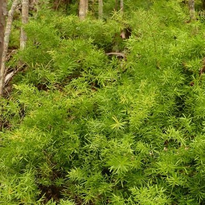
Ground Asparagus
Asparagus aethiopicus ‘Sprengeri’Forms dense thickets. Can reduce native plant regeneration and plant biodiversity across the infested areas.
Alter wildlife composition in infested areas.
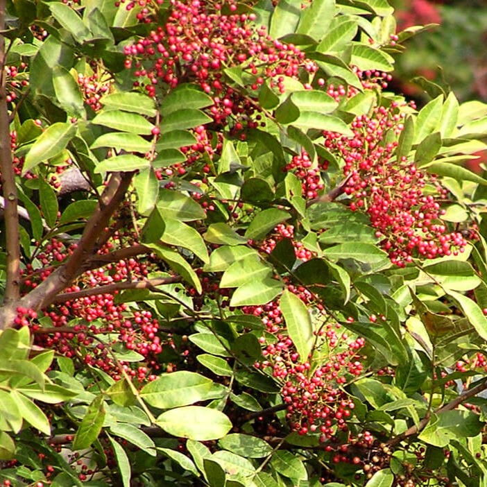
Broad-leaved pepper tree
Schinus terebinthifoliusCan reduce native plant regeneration and plant biodiversity across the infested areas.
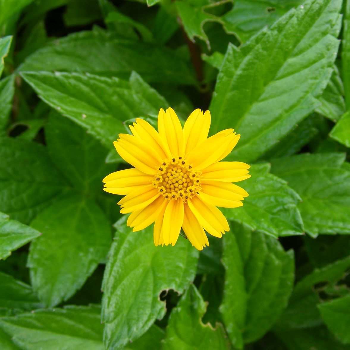
Singapore Daisy
Spagneticola trilobataAggressive, quick growing groundcover.
Can reduce native plant regeneration and plant biodiversity across the infested areas.

Mile-a-Minute
Ipomoea cairicaSmothers native vegetation, with the risk of impacting the health of the tree. Can reduce natural regeneration in infested site.
How you can help:

Human access:
Another key strategy is managing human access to minimise erosion. Boardwalks, designated pathways, dune fencing, and interpretive signage help direct visitors away from sensitive areas.
Restricting vehicle access is especially important, as off‑road driving destroys vegetation, lowers dune height, and accelerates blowouts. Vehicles should limit driving to between 1.5 hrs either side of low tide.
In urbanised or high‑use coastal areas, well‑designed access infrastructure can significantly reduce trampling pressure while still enabling recreation.
How you can help:


Sediment supply:
Preserving natural sediment supply is vital for long-term dune resilience of dune systems, particularly in the face of climate change. Longshore drift, beach–dune sediment exchange, and offshore sand reservoirs all contribute to dune growth. Coastal engineering structures, such as seawalls, groynes and breakwater, can disrupt sediment pathways and starve dunes, leading to erosion and ecological decline.
Where possible, dune management prioritises soft engineering approaches over hard structures.

Join the wave of citizen science – Grab a snap for CoastSnap
CoastSnap is a global citizen‑science program that empowers everyday beachgoers to help monitor and understand how coastlines change over time.
Using simple fixed camera cradles installed at beaches, or a location of your choice, participants use their smartphone to take a photo, and upload it through the CoastSnap app. Each photo becomes part of a long‑term record showing how shorelines shift in response to storms, sea‑level rise, and other natural and human‑driven processes. This data will help us better understand and safeguard our changing coastlines into the future.
Seas the moment—snap the coast! Download the App today!

Explore more about our beautiful coastal dune systems via the Noosa Coast: Coastal Custodian Guidebook by local legends, Sharyn Kerrigan & Rochelle Gooch.
This independently funded, community‑initiated guidebook gives you easy access to proactive coastal education—whether you’re a local resident or a visitor—so you can build your knowledge, understanding, and appreciation of our coast. By offering the interactive publication freely online, this guide aims to empower you to deepen your awareness and take meaningful action to protect your local coastal environment. Hard copies of the guide are also available from our Hinter Hub Retail Nursery and Gift shop.